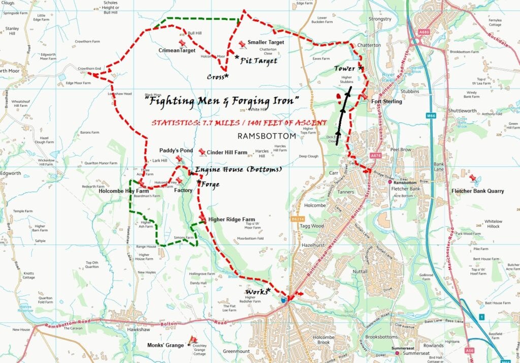
Fighting Men & Forging Iron

In The West Pennines
~
~
~
* Tentering Tower


The Tower at Stubbins ~ Stretching on tenter hooks
~
This is an unusual building in that its purpose seems to have been twofold. It served not only the textile industry (the woollen mill at the bottom of the hill) but also was built in such a way that it acted as a point of focus on the landscape … someone was showing-off!
The process of tentering was important in the manufacture of textiles and the term ‘tenterhooks’ is still in common use to describe being in a strained state of anticipation. Tentering involved the stretching of newly made cloth fixed to wooden frames by a series of sharply pointed hooks, this allowed the cloth to keep its shape whilst it dried. Usually, the tentering frames were located in rows on sheltered and sunny slopes, but this one was undercover to afford protection from the region’s rainy climate.
It is uncertain whether this tower was used solely for tentering or also for the storage of cloth either before or after it had been stretched.
The building, made from local stone with plaster and timber lining, demonstrates the confidence and self-assurance that the industrialists felt at the time and may have also been built to deliver a strong message to their competitors. It was originally only one story, but an extra level was added, hence the odd positioning of the staircase … an afterthought! The square tower was meant to be seen as an eye-catching local landmark so it is positioned at the edge of the hill with steep drops below it. There are ornamental battlements topping three sides as can be seen from the village below. There are no battlements on the west (rear) side, this is where the workers accessed the tower … obviously, no expense was thought necessary here!
The factory to which it belonged was Stubbins Vale Mill. The mill was built in 1851 as a manufacturing plant that produced woollen cloth … the tower was constructed soon after, in 1866. It was owned by a local textile manufacturing family … the Porritts. The family is still remembered with fondness and the death of their only son, Richard, early in WWII, was seen as a tragic loss for both the family and community. Richard bequeathed nearly 500 acres of the Stubbins Estate to the National Trust, including the magical Ox Hey Woods and Buckden Woods … we enjoy exploring both on this walk!
~
* Targets

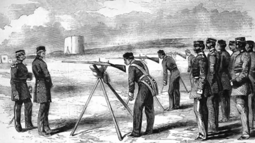
Target Pit ~ Enfield practice 1859
~
~
Bury and these moors are synonymous with the Lancashire Fusiliers. However, they did not come to the town (Wellington Barracks) until the 1870s. The regiment originated as the 20th Foot in Devon, so why did they move here? … we are in the heart of Industrial Revolution country, prime for recruiting from the booming population. In recognition of the county, they changed their name to the LFs in 1881.
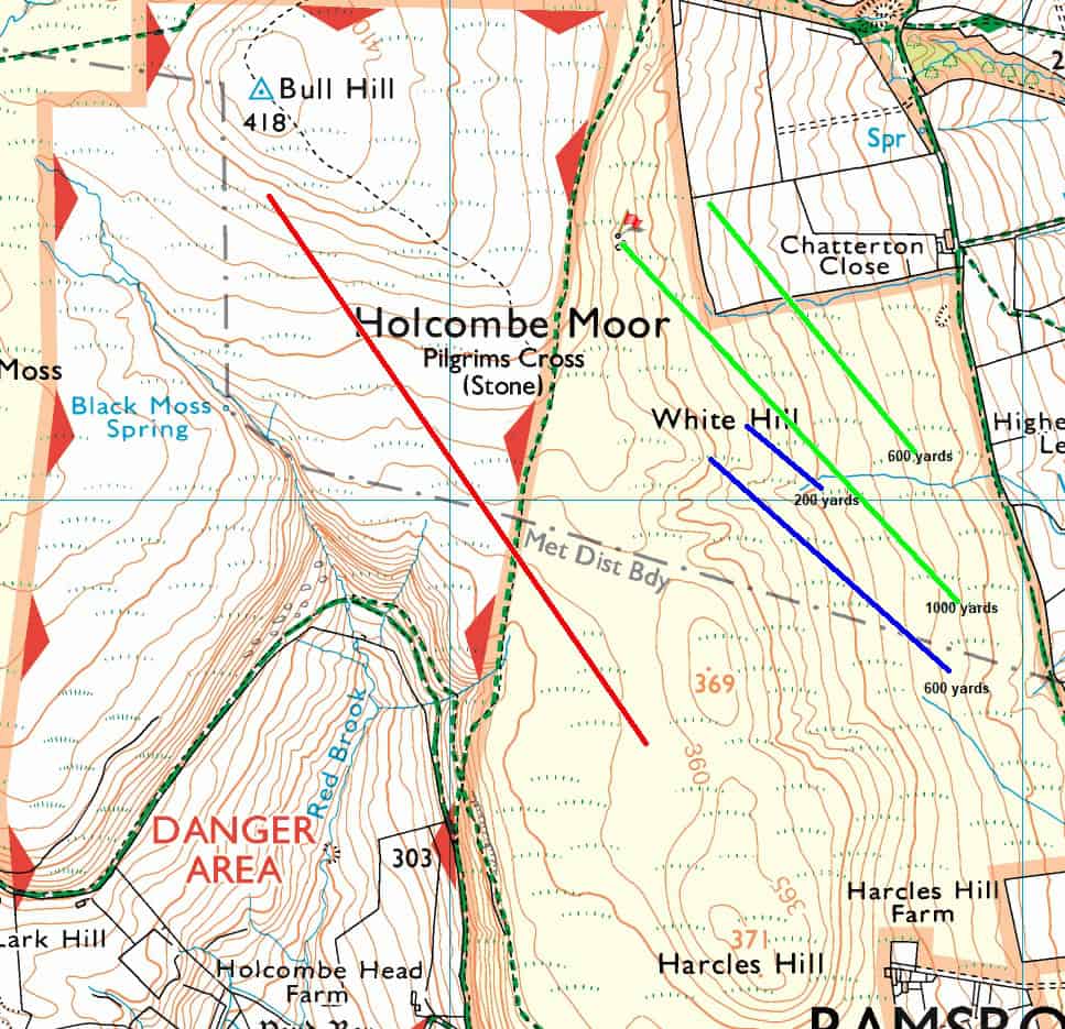
From the mid-19th century, there was a rapid development of firearm hardware. Up to then, muskets were used … they would have been lucky to have reached 100 yards! The current firing range towards Hawkshaw (on the Reddisher Estate) is a multi-target complex (including provision for machine-guns), but wasn’t opened until 1912. There are three simpler ranges that are much older and located around Bull Hill and White Hill.
RANGE ONE – 1853 – Britain was preparing for war against the Russian Empire. It was in response to Russia’s attempt to dominate Turkey. The Crimean War (1854-57) was remembered for great gallantry but also great incompetence!
The 88th Regiment of Foot (later to become The Connaught Rangers) was briefly barracked at Bury. They were camped on Harcles Hill, hastily trying to get used to the newly introduced Pattern P53 Enfield musket rifle. The lead cylindrical bullets could reach their cast-iron targets up to 1000 yards away. Our target of interest lay on the western slopes of Harcles Hill to the western slopes of Bull Hill.
The 88th went on to see action at Alma, Inkerman and Sevastopol.
RANGE TWO – 1860 to 1898 – in 1859, the perceived threat once again came from France (Napoleon III).
This range was used by the 57th Volunteer Rifle Corps, based in Ramsbottom and Tottington. This period saw a further progression in rifle and bullet technology. The targets would have been made of cast or wrought iron. The shooter would need to know exactly where he had hit the target, so another soldier (a marker) would stand offset 15 yards away from the target behind a shield (mantlet). He would indicate the location of the shot on a dummy target positioned above the mantlet.
Soft lead bullets hitting the iron target would disintegrate, contaminating the ground around and stunning vegetation for many decades!
RANGE THREE (the pit is flagged) – 1898 – 1914 – by now, the 57th Volunteers (precursor to the Territorials) were part of the 3rd Corps K Company (Ramsbottom).
As emphasis on safety came to the fore, targets now were made of penetrable canvas stretched over a wooden frame. The marker could mechanically withdraw them behind the safety of a mantlet to be scored and patched. The common practice (as here on Holcombe) was to dig a dedicated target pit.
The pit remains to this day. It measures 45 x 15′ and is lined with dressed stone, it has a flight of steps leading into it. Its size suggests four targets could have been accommodated. There was evidence of a degraded low mantlet protecting the pit, but no trace of a purpose-built stop-butt. It was assumed that the naturally rising soft ground to the rear of the pit was of sufficient height and angle to safely retain bullets. A search of the area has only produced a few .303″ bullets.
~
* Pilgrims’ Cross


~
A number of authors have claimed that Medieval pilgrims passed here, to pray and rest, on their way from Manchester Church (Cathedral?) to Whalley Abbey. There is some conjecture about this because the facts don’t entirely add up … Manchester was an insignificant village back then and held no important religious relics to attract the pilgrims. The cross was first referred to in 1176 (but was probably much older … Saxon), Whalley Abbey didn’t exist then! … although Whalley Church did and also Sawley Abbey (a little further to the east), was this their destination? Geographically, all does add up … draw a straight line between Manchester Cathedral and Whalley … Pilgrims’ Cross lies nicely on the ‘flight path’! (from the 1780 map, there was an ancient highway running from south to north and very close to this site).
The original cross was estimated to stand ten feet high. It is thought to have been destroyed during the Civil War … perhaps by local farmer, George Whowell, in revenge for his family being attacked and murdered by Royalists. Whowell also offered to be (and was) the executioner of James Stanley, the Earl of Derby in 1651! The large cube-shaped monument that stands to-day on the site of the Pilgrims’ Cross, tells a story on each of its four sides. The socket that the cross stood on was destroyed by vandals in 1901 and in 1902 the present monument stone was put in place.
Monuments on ridgeways like this would have been invaluable guideposts for Medieval travellers, both as a means of knowing how far you have travelled and as a way to orientate yourself in bad weather. Navigating by landmarks would have been crucial in upland and moorland environments, so crosses and large prehistoric burial mounds would all have been named. Originally, this monument was known as Whowell’s Cross and Chatterton’s Cross.

The Holcombe Moor Heritage Group and Greenmount Village Walking Group have created the 35-mile ‘Pilgrim’s Way’ … a description of a countryside route from Whalley to Manchester. Although much of the landscape has changed since the early 19th century, it connects many interesting Saxon remains along the way.
I have converted this description into a 1:25k walking o/s map.
St.Mary’s Church, Whalley > St.Bartholomew’s Church, Great Harwood > St,James’ Church, Church Kirk > St.James’ Church, Haslingden > Robin Hood’s Well > Pilgrims’ Cross > Affetside Cross > Church of Christ, Cockey > St.Mary’s Church, Radcliffe > (I have added) Kersal Cell > Manchester Cathedral and ‘The Angel Stone’.
The journey did not end at Manchester, but continued to Derby and onto Lichfield … using Roman roads and Saxon portways.

Should you get chance to visit the pub at Affetside, you might notice a macabre human skull(?) … it belongs to George Whowell!
~


St.Mary’s, Whalley ~ Manchester Cathedral
~
*Iron Forge


Bay (Paddy’s) Pond ~ Bloomery

~
Marked on the map in Gothic writing is “Paddy’s Bay” (this water feature was later restored by the MoD as ‘Paddy’s Pond) which is thought to be the location of a Tudor iron works. Further to archaeological investigation, the date and location are now proven to be incorrect!
The location of two bloomeries (a bloomery is a furnace used for smelting iron ore) was discovered a little further to the southeast in Cinder Hill Field.
According to local history, the iron workings in this area were assumed to be Tudor (1485-1603) in date. However, evidence from the excavations has shown that the activity on the site took place during the 12th-14th centuries. Charcoal fragments were carbon tested and many contemporary fragments of Medieval (1066-1485) pottery sherds were discovered during the project. This dating fits in nicely with the period that the Priory of Monk Bretton at Barnsley owned vast estates (from 1225 until the 1539 Dissolution), including here at the Forest of Holcombe. The monks needed high-quality tools for ploughing, sheep clipping, tree felling, butchery and building tools.
Although the location of the iron ore has not been confirmed, it would have probably been extracted from the immediate vicinity. In addition, it could have been brought onto the site from further afield. The charcoal for the furnaces would have been produced in the valley, because it could not be easily transported due to its fragile nature. There are certainly iron ore seams in the valley which can be seen in the eroded banks of the brook.
Once mined, the ore would have been washed, probably in Red Brook (perhaps its naming comes from the leeching of iron ore into the stream), then it would be roasted on open fires to start the chemical reactions needed in the smelting process. The ore would then be mixed with the charcoal and placed into a shaft furnace, constructed using the clay that is found in many places throughout the valley, where it would be heated to around 1100-1300 degrees Celsius until a bloom of wrought iron was formed in the furnace. Any waste would be removed from the furnace by means of “tapping” the base of the furnace to allow the molten slag to flow out. The bloom would then be taken to a smithing hearth (string hearth) and then re-heated and hammered until the bloom was converted into a bar (or billet) of wrought iron which would then be either sold or used to make iron tools.
FURNACE LOCATION - from the Engine House > cross the brook over the footbridge > follow the path to the right of the seating circle up onto Cinder Hill Field > as you walk by the trees on your left > you may notice that there is a flatter area towards the top of the field > this is the siting of two very well preserved bloomery furnaces (excavated 2018 - 2023)
~
* Engine House


~
These intriguing ruins are that of an early Industrial Revolution engine house. Cinder Hill Engine House was constructed between the late 1780s and the early 1790s. It was built by Laurence Brandwood and run by his son John, they lived at nearby Holcombe Hey Fold Farm and Cinder Hill Farm.
Initially, the engine house was a small, three-storey, building and it may well have carried out all the processes of textile production. A typical arrangement might have carding > spinning > weaving … each process occurring on a separate floor. The spinning was powered by a 16-foot diameter water wheel. The archaeology showed that this was fed by a ‘breast shot’, meaning water was fed in level with the axle of the wheel, and then flowed down and under the wheel to turn it. A reservoir at the back of the building fed the water to the wheel. In turn, the reservoir was supplied by a leat from a weir 100 yards upstream of Red Brook.
Machine parts recovered in the excavation could be pieces of spinning machines, possibly showing they were using technology such as Richard Arkwright’s Water Frame or Samuel Crompton’s Spinning Mule. Archaeological excavations have revealed that the water wheel had to be repositioned at some point (a stone plinth was placed over where the wheel stood). This could be because it had become twisted or the machinery it powered had been modified. An unusual feature in the ruin is the large fireplace. This may have contained a large cauldron of boiling water. The water vapour produced could have kept the humid air in the room damp to facilitate spinning. The stonework next to the footbridge once supported a trackway that went over the brook and made its way up the eastern side of the valley and joined up with Moorbottom Road.
In 1825, the Cinder Hill Estate was taken over by John Parker, a very wealthy cotton spinner. He constructed a new building 200 yards downstream … the Cinder Hill Factory, a cotton waste spinning mill.
The engine house was then put to a different use … the wheel pit was filled in and the building was now being used for bleaching or some kind of finishing process for the textiles produced in the new factory downstream. By the late 1830s, the bleaching and finishing process was no longer required. The former engine house did not, however, fall into disuse … it was converted into accommodation (three cottages) for some of Parker’s workers and became known as ‘Bottoms’. By the 1870s, in line with the factory, the cottages fell into disuse.
In the years just before WWI, the army took over this part of Holcombe Moor, they have stayed here ever since. During the 1970s, all the remaining farm buildings and ruins in the valley were demolished under the orders of the MoD.
~

Although drystone walls are a familiar sight on our walking adventures, the vertically placed rectangular slabs we come across on to-day’s walk are less well known. They are called ‘vaccary walls’ … vaccaria in Latin means cows. They were used to restrict the movement of livestock, particularly cattle. They are similar to ‘shard fencing’ (interlocking stone slabs) in the Lakes.
~
* Redisher Bleach & Dye Works


~
Here once stood Redisher Works, built next to Holcombe Brook. It also came within the boundary of land granted to the monks of Monk Bretton Priory during the late Medieval period and lay in very close proximity to the site of a manorial corn mill first mentioned in 1246.
It was probably established in the early 19th century, and by 1841 it was a bleach work operated by Ambrose Wilkinson. From the 1840s to 1860s, it was a large rectangular two-storey building, powered by both a waterwheel and a small steam engine, surrounded by three large reservoirs. Between 1850 and 1864, the success of these works resulted in the construction of another building, listed in historical records as a “chemical works”.
The business was purchased by Samuel Knowles in 1866. He was important to the local textile-finishing industry, owning the nearby Tottington & Kirklees printworks, and introduced ground-breaking techniques of textile printing. Under his ownership, the buildings and reservoirs were modified, and he also established a small brickworks. The site was further enhanced in 1882 when a branch railway was opened (over the main road where the precinct now is), operated by the Bury & Tottington District Railway Company. This greatly improved transport, allowing coal to be delivered cheaply, and was part-funded by Samuel Knowles to connect his textile-finishing works to Bury, and ultimately Manchester.
Samuel Knowles & Co sold the Redisher Bleach Works to Charles Ainsworth in 1898, whose family had bleach works at Bolton. He was also influential locally, being the Conservative MP for Bury between 1918 and 1935. Following the takeover, the site diversified incorporating dyeing … being renamed the Redisher Bleach & Dye Works. The works had expanded by the 1920s, comprising an L-shaped range surrounded by ancillary buildings. It continued to operate until its closure in 1961 when it had 80 employees.
Both circular and rectangular dyeing vats were excavated here, prior to the building of the housing estate. One of these vats has been replicated at the site of the brick information site. The circular vats (‘dye vessels’) were used to mix dyes in the early 20th century works. A mordent, traditionally alum, was added. These were replaced in the mid-20th century by the rectangular vats (‘dye becks’) used to dye cloth, by which time synthetic dyes were introduced.
~
Holcombe Brook developed as a village in the early 19th century when it became the crossroads between two major turnpike roads, converging at Alter Bridge (the junction outside the Hare & Hounds) and crossing of the brook itself.
~
INFORMATION:
DISTANCE: 7.7 miles
CLIMBING: 1401 feet
ORIENTATION: Linear/East to West
START: Ramsbottom / FINISH: Holcombe Brook
BUS: Outward – No.472 Bury Interchange Stand P > Cross Street Stop C, Ramsbottom
BUS: Inward – No.474 Opposite Hare & Hounds, Holcombe Brook > Bury Interchange
END OF WALK PUB: Hare & Hounds, Holcombe Brook
EATING PLACES: The Bower, HB / Hare & Hounds, HB
COMMENTS: Exposed moorland crossing / IF RED FLAGES FLYING, YOU WILL BE UNABLE TO CROSS MoD LAND … ALTERNATIVE ROUTE ON MAP – – – – –
https://www.gov.uk/government/publications/holcombe-moor-firing-times.
DOGS: On lead at all times (plus on buses). All facilities in HB are dog-friendly
PRODUCED AND NARRATED BY: Vinne Anderson
CAMERA WORK BY: Jon Shedwick
MUSIC: “The Lancashire Fusiler” by The Houghton Weavers
INCIDENTAL MUSIC: “Over The Moors” by Stockton’s Wings
DISCLAIMER: No drone shots were taken from or over MoD land
~

~
SOURCES OF INFORMATION: TURTON LOCAL HISTORY SOCIETY / HOLCOMBE MOOR HERITAGE GROUP / HOLCOMBE HISTORY SOCIETY / 28 DAYS LATER / RAMSBOTTOM HERITAGE SOCIETY
ACKNOWLEDGEMENTS: GATIS ODINS / BILL FLENTJE / KEITH BURROUGHS / SYLVIA WALCH / NEIL COLDRICK
This was ... "Fighting Men & Forging Iron"
The Blue Fox Team will return in ... "Stand & Deliver"
~
Pilgrims’ Way … In Pictures


St James’, Haslingden ~ Robin Hood’s Well, Holcombe Moor


Ellen Strange’s Memorial, Holcombe Moor ~ Pilgrims’ Cross, Holcombe Moor


Cross, Affetside ~ Christ Church, Cockey


St Mary’s, Radcliffe ~ Tower, Radcliffe

