Cycle Special – Leeds&Liverpool Canal (2015 & 2025)
Our original 2015 story …
Jon and I have covered many parts of the canal on many occasions and had often talked about paying homage to this magnificent engineering wonder, by exploring its entire length in one go!
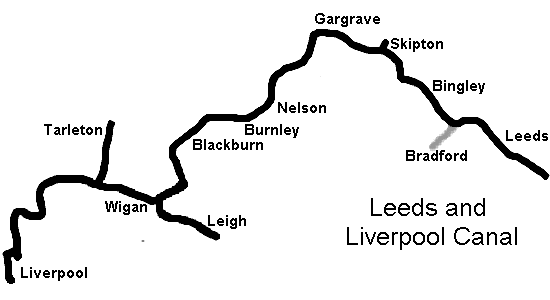
We hadn’t got access to a narrowboat … but we sure did have bikes, and were forever up for an adventure! This is an incredibly simple idea and, with only a minimal amount of organising, was easy to put together … in May 2015 we executed our plan, it turned out to be a phenomenal success. History ~ The Leeds & Liverpool Canalwas the lastof the three trans-Pennine canals. It has a mainline of 127.25 miles long, making it easily the longest canal built by one company in the country! It links the Aire & Calder Navigation at Leeds with the northwest seaport of Liverpool, forming a through route between the North Sea and the Irish Sea. Although the last 1/4 mile (Liverpool end) has been filled in, it is still possible to complete the route via Eldonian Village.
Cycling The Route ~ The conventional way to travel by bike would be to go west to east, to take advantage of probable prevailing winds … so let’s defy logic and tackle it the other way. I have reckoned that, although canals can get rather exposed to headwinds, the latter stage of the route is the more gentle. Also, it would seem more natural for us to head westwards and towards ‘home’.
It is possible to cycle the towpath along the whole canal, the only exceptions are two tunnels at Foulridge and Gannow. Navigation is not an issue and there aren’t any major junctions to confuse you (it is well signposted anyway). That said, a 1:50000 set of maps is required to pinpoint your position in relation to the daily section you are travelling on, to locate facilities and for any necessary diversions due to unexpected towpath maintenance.
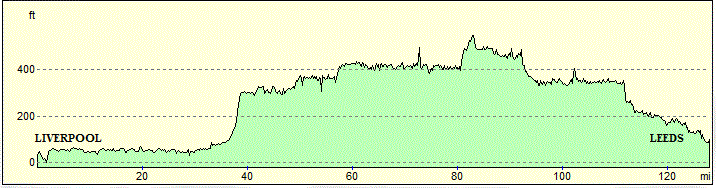
Track Elevation ~
To get to and from our start/finish points we used the train … taking us into and out of the mighty cities of Manchester, Leeds and Liverpool.
DAY ONE ~ Leeds to Earby = 42.6 miles / 2100 feet ascent / 1700 feet descent / 5:20 hours:mins + breaks
DAY TWO ~ Earby to Wigan = 50.7 miles / 2100 feet ascent / 2500 feet descent / 6:20 hours:mins + breaks
DAY THREE ~ Wigan to Liverpool = 37.9 miles / 650 feet ascent / 700 feet descent / 4:44 h:m + breaks
Based on a blanket 8mph
~
Costings~an INCREDIBLE £101pp: this includes train fares/accommodation/meals (breakfast, packed lunch, evening meal) … you need to book well in advance to get the best deals.
~
Full map details (the route, places to eat, toilets, cycle repair shops, food stores etc) and suggested accommodation details are available on request … it’ll cost ya a pint! … VA
~
TIPS & HINTS …
Here are some pointers for anyone considering following in our tyre tracks:
Cycle – mountain bike/ensure that it is well maintained and in good working order/anti-puncture road tyres / comprehensive tool kit/bell … it will get well used!
Luggage– travel extremely lightly/35-litre rucksacks as opposed to panniers/clothes and gear in separate waterproof bags/first-aid kit
Duration – we did this in 2 nights & 3 days/you may wish to consider 3 nights & 4 days(?)
Timing – from May to September/mid-week is strongly advised … although you will have large swathes of the canal to yourself, you will be competing with many walkers in built-up areas (ESP. weekends)
Accommodation – range enormously; limited hostels, motels ideal/ensure that your choice has cycle storage facilities
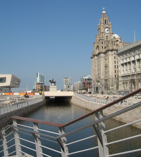
Direction– I categorically defend my decision to do this east to west/you are probably going to do this in the summer and will be unlucky for strong winds to be a factor/see the above elevation guide (ie a flat ending)/Liverpool’s waterfront makes for a majestic finale
Navigation–the beauty of this route is that it is extremely easy to follow/you will need however to come off the towpath on occasions … there are two tunnels where you will need to go ‘over the top’/there could be sections closed where work on the towpath is being carried out/you will need to exit for your accommodation or for facilities
Maps – although we did use an array of gizmos … gps, I-Pad and smartphones .. the bedrock of my navigation came from good old RELIABLE paper maps/I used 1:50,000 O/S digital mapping, segregated into 3 sections/in addition, I used 1:10,000 (Streetmap) for locating our accommodation/I have devised a simple and highly effective method of quickly pin-pointing your position while travelling on canals (Copyright: ME!!! ???)
BRADFORD BRANCH
History ~ Opened in 1774 to connect Bradford to the Leeds & Liverpool. It thrived for nearly a hundred years, being an important route for exporting goods produced in Bradford. There were always problems with the water supply, sources were unable to provide enough water to keep the locks going. It became highly polluted and was virtually an open sewar!The Bradford Canal reached its peak in 1910, but trade stopped during WWI and it was officially closed in 1922.
The Route ~ Very little of the canal now exists, having been completely swallowed up by city developments. A small nib at the junction at Shipley is still intact (used as a winding hole), and the odd rare remnant is still visible as the branch made its way into the heart of the city at Eastbrook.
~
SPRINGS BRANCH (walked 2017)
History ~ Opened in 1797, this branch runs from the heart of Skipton for half a mile around the back of Skipton Castle to a former stone-loading wharf. It was built for Lord Thanet, who lived in Skipton Castle and owned the limestone quarries situated here. Stone was brought from the quarries by a tramroad to be loaded into boats for the journey down to Leeds.
WalkingThe Route ~ From the heart of the town, it is possible to walk along the towpath (still navigable to small boats) to the lofty foot of the castle. A sublime stretch of woodland and climb to the perimeter of the canal itself. Return is through the bustling market town.
2 miles
~
WALTON SUMMIT BRANCH (on the very long “to do” list)
History ~ Opened
Walking The Route ~ Opened
~
LEIGH BRANCH(cycled 2015)
History ~ This was not opened until 1820, it connected into the Bridgewater Canal and the capital of cotton … Manchester. The craft could now avoid having to cross the Mersey Estuary to travel south.
Cycling The Route ~ A short train journey is required from Manchester to Wigan (£4.20). The route follows the main L&LC line, before branching off to Leigh, where it conveniently meets the Bridgewater all the way back to the heart of Manchester at Castlefield.
The towpath is by and large extremely well surfaced, although there are some original stretches that could be prone to mud(?). There is a short section around Astley Green where cycling is prohibited (you will have to dismount, plus negotiate some awkward gates!!!).
History ~ From 1740 until the late C18th boats wishing to travel from Wigan to Preston did so via the River Douglas. The Rufford Branch of the L&LC, also known as the Lower Douglas Navigation, provided an alternative route for much of the distance. It was opened in 1781, long before the mainline was completed in 1816.
Cycling The Route ~ As this is a circular, the car can be used to get to the start/finish point. This tranquil route is more interesting than spectacular, as it slices through the flat and fertile Lancashire Coastal Plain.
The outward journey ends as canal meets river and is cycle unfriendly thereafter. This would only suit the driest of conditions as it could be susceptible to thick mud. The inward journey is a mix of road, country lane and nature reserve paths.
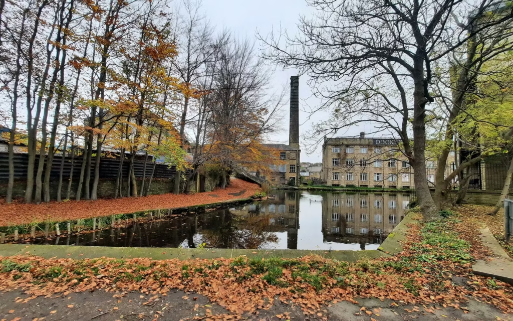
History ~ The original terminus of the L&LC was at Clarke’s Basin (around Old Hall Street in Liverpool). It was built in 1792 and closed in 1886 (to accommodate the expansion of the railway) and was the closest link the canal had to the dock system until the Stanley Dock branch was built in 1846. Cargo would have to be transhipped from boat to waggon and then taken to the docks. It was realigned and moved slightly east to Pall Mall.
In 1978, a local housing group from Eldonian Street were told they were to be re-housed and the community split up. They protested and the Eldonian Village plan was created. The area was cleared and the canal shortened yet further. The demolition of the Tate & Lyle sugar refinery marked the end of the canal as an industrial feature.
Walking The Route ~ Although this officially starts at the point we entered Liverpool at the Stanley Docks flight of locks, it can be conveniently picked up anywhere on the route.
Very little of the original canal exists beyond Eldonia and present surroundings are somewhat saddening on the eye! but small reminders from the past can be seen and a great sense of its historic course can be gleaned.
4.5 miles
Our 2025 revisit, a fresh perspective …
~
DAY ONE ~ Leeds to Gargrave = 34.7 miles / 1276 feet ascent / 993 feet descent / 4:20 hours:mins + breaks (blanket 8mph)
This is as good a canal side cycle ride as it gets! Towpath maintenance and upgrading must be akin to “painting the Forth Bridge”, full credit to all concerned for making this section a joyous experience … affording for a silky traverse through Yorkshire to the outskirts of Lancashire.
~
DAY TWO ~ Gargrave to Wigan = 58.0 miles / 2294 feet ascent / 2560 feet ascent / 8:03 hours:mins + breaks (8mph and 4mph sections)
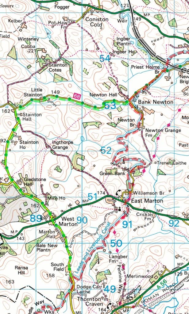
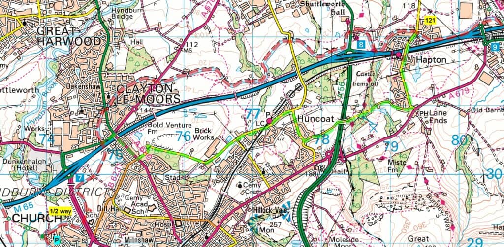
In contrast, the towpath on this day ranges from adequate to downright woeful! This is a long and demanding day. The sections between Bank Newton and West Marton (near the start) and again between Hapton and Enfield (Clayton-le-Moors) are extremely challenging to cycle. I have devised road/lane diversions to compensate.Also, be aware that it is a long day and there are very limited facilities … ensure you allow plenty of time and pack provisions.Consider doing this in two days.
~
DAY THREE ~ Wigan to Liverpool = 38.3 miles / 629 feet ascent / 660 feet descent / 5:02 hours:mins (8mph and 6mph sections)
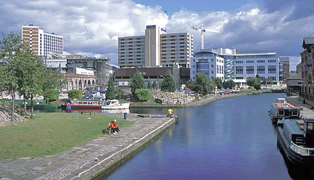
A flying start right up to Parbold should ease you into the day nicely. Thereafter, all the way to the outskirts of Liverpool at Maghull, the route becomes very rural and the towpath is narrow and demanding … full concentration is required. Your reward is a magnificent finale all the way to Liverpool’s waterfront and the ‘steps’ of the Liver Building!
~
The big conclusion …
Cycle – all things considered, hybrid bike for three days and mountain bike for four days. NOTE *** in no way whatsoever, by opting for a mountain bike, am I suggesting that anyone should cycle the two problematic sections at any time other than the driest periods … all this will do is exacerbate the situation by churning up the ground further!USE the road alternatives (regardless of bike) in wet conditions.
Luggage – as above plus phone/gizmo chargers.
Duration – for three days = Gargrave > Wigan, for four days = Gargrave > Burnley > Wigan. You may also wish to consider an extra day at the end in Liverpool(?).
Timing– this time around, we started on a Sunday. Although there was increased towpath activity, the journey to Leeds was quieter and there was a greater chance that canal side facilities were open.
Accommodation – although we have no affiliation with Premier Inns, we used them throughout (using the ‘ you know what you are getting’ logic). They suited all our needs and requirements and afforded us uniformity and consistency. Cycle storage is allowed in your bedroom, but this might not apply to e-bikes (fire hazard).
Direction – as above.
Navigation – as above plus I reiterate that there will be the need to come off the canal at some point … accommodation, refreshments, cycle repairs or medical emergencies (resources can be pinpointed on your smartphone). Towpath closures can be researched in advance via the Canal & River Trust website, diversions will be displayed at the point of closure but it is best to plan your own in advance from the comfort of your home. What you will not be aware of are sudden closures … expect the unexpected when it comes to canals!
Maps – as above plus … this is the big game-changer! Advances in technology now dispense with the need for awkward paper maps.Different gadgets for different people, but this is what I use … a dedicated heavy-duty smartphone > digital mapping (Memory-Map) > a variety of OS scales > 1:50k is adequate for the mainstay > 1:25k for detail if required > 1:10k ‘Streetmap’ for town navigation. Attached to a holder on my handlebar, I could easily see where along the section we were up to … 1/4 way, 1/2 way etc. Armed with this, I could tackle any detour (ensure you are fully charged before each journey and take a battery bank as back-up).
Trains – cycle storage on trains ranges from inadequate to inadequate! and there are different rules for different operators to contend with (TransPennine Express is the likeliest). Tickets, train times and platform information are far easier to access nowadays, again turning to smartphone technology to assist (we used the ‘Trainline’ app). You may need to obtain a reservation ticket (free) for your cycle (pick up at a ticket machine at the station).
Towpaths – as discussed. I have put maps of my suggested two main road alternatives (in green) below …
–
The number in the yellow box indicates the bridge exit point, they are also on all relevant exits … a very useful navigation tool!
~
I haven’t produced a gallery page this time, but Mareks has put something on his hugely popular ‘Tiktok’ account … greatadventureswithmaz