M 2 M Cycle Tour (2016)

 M~2~M 2016
This is our most ambitious holiday so far (8 days in the saddle!). It is  another area I am very familiar with (albeit in a walking and drinking capacity!) and reckon I have once again conjured up a lot of contrast and mischief. Scenically, it will have a VERY different feel to the other holidays, and will be extremely undulating in parts and very gentle in others … we will be sandwiched between majestic moors and magical seas, with the odd mysterious hidden valley and memorable estuary crossing thrown into the equation!
I have built in some challenging off-roading sections for the more adventurous and easier (but maybe less pretty) options where I deem it necessary. Any increased climbing will be reflected in the decreased distance.
Archive …
Introduction:
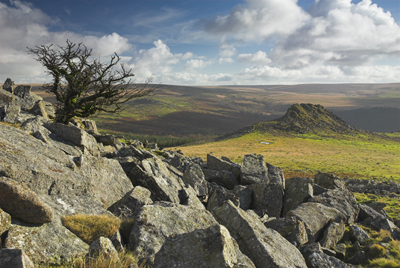
In trying to mirror the peninsular, the route takes on a ‘horseshoe’ shape. After making our ‘entrance’, courtesy of The West Somerset Steam Railway Company, it starts on the outskirts of the unique remote wilderness of ExMoor and slices right through the breathtaking expanses of DartMoor. It is not all about moors though … if there’s one thing we Brits love, it’s the sea! … brace yourself for a ‘picture postcard’ fix like no other … complete with that very British institution .. The Pub!!!
E x M o o r ~ D a r t M o o r

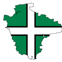
With contributions from the county of Somerset and Exmoor & Dartmoor’s little cousin … Bodmin!
 –
–
–
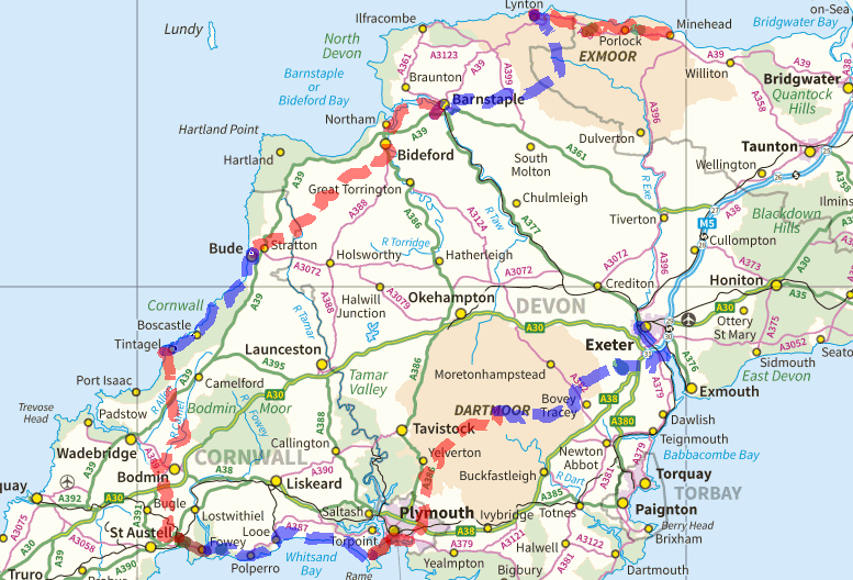
<<< Minehead
<<< Lynmouth
<<< Barnstaple
<<< Bude
<<< Tintagel
<<< Par
<<< Kingsand
<<< Bellever
<<< Exeter
–
–
I have outlined the following below: Costings / Statistics / Itinerary / Training Routes / see also our “Cycling Holidays” Page, for additional information …Vinnie
~
Costings:
(Manchester based): Transport – Private Cars (Petrol + Parking) = £30 + £15pp
Accommodation + All Food (breakfast, packed lunch and evening meal) = approx. £454.00pp Steam Train = £19.10 Toll Roads = £1.00 (2015) Cliff Railway = £5.70 Ferry Crossings = £4.25 Train Exeter to Taunton = £11.40 TOTAL = £540.45 (8 full days) To try and draw some parallels .. the C2C TOTAL was £380pp (6 full days) and the B2B was £405pp (7 full days) … all INCREDIBLE bargains!~
Statistics:
To give you a statistical comparison, we completed the
C2C in 6 days / 168 miles / 15324 feet of climbing (if the extra leg, that Jon and I did, is included then 7 days / 189 miles / 17071 feet)
B2B in 7 days / 207 miles / 16705 feet of climbing
NoR in 6 days / 172 miles / 12650 feet of climbing
M2M in 8 days / 235 miles / 28675 feet of climbing
| C2C
Prestwich to St Bees 128 miles Keswick 27.5 miles / 3010 feet Patterdale 15.6 miles / 2182 feet Kirkby Stephen 30.5 miles / 2537 feet Richmond 33.7 miles / 3566 feet Great Broughton 29.8 miles / 877 feet Whitby 30.3 miles / 3152 feet Scarborough 21.0 miles / 1747 feet Whitby to Prestwich 117 miles
|
B2B
Prestwich to Chepstow 181 miles Ross on Wye 31.1 miles / 3453 feet Leominster 29.8 miles / 2142 feet Bridges 35.0 miles / 3956 feet Ellesmere 31.7 miles / 1444 feet Llangollen 22.9 miles / 1815 feet Ruthin 21.1 miles / 2854 feet Llandudno 35.2 miles / 1041 feet Llandudno to Prestwich 89 miles
|
| NoR
Prestwich to Keilder 157 miles Kelso 36.5 miles / 3050 feet Berwick on Tweed 32 miles / 1850 feet Holy Island 14.5 miles / 600 feet Alnwick 38.5 miles / 2250 feet Byrness 36.5 miles / 3500 feet Keilder 14 miles / 1400 feet
Keilder to Prestwich 157 miles
|
M2M
Prestwich to Taunton 222 miles Lynmouth 21.3 miles / 3263 feet Barnstaple 27.8 miles / 3383 feet Bude 36.7 miles / 2769 feet Tintagel 20.0 miles / 3004 feet Par 31.1 miles / 3147 feet Kingsand 30.5 miles / 4883 feet Bellever 29.7 miles / 4252 feet Exeter 34.8 miles / 3973 feet Exeter to Prestwich 255 miles |
DAILY AVERAGES (Distance & Climbing): C2C = 28m + 2554′ / B2B = 29.5m + 2386′ / NoR = 28.7m + 2108′ / M2M = 29.0m + 3584′
FEET OF CLIMBING PER MILE: C2C = 91′ per m / B2B = 81′ per m / NoR = 74′ per m / M2M = 124′ per m
~
Itinerary:
ARRIVAL DAY: Saturday 10th Sept – Prestwich Rendez-vous: 07:00 @ Sanderson Towers + All Rendez- vous: 14:00 @ Bishops Lydeard Station
Journey time from Prestwich = 4.5 hours 225 miles, this includes 30mins break at Strensham Services, this is 1 hour 40 mins from Taunton
Cycle from Taunton to Bishops Lydeard = 5 miles
Steam Train @ 14:35 (cycles booked for this one, but we have an open ticket … next train 16:20)
ACCOMMODATION – Independent Hostel, Minehead
~
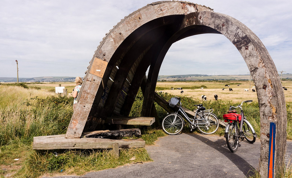
DAY ONE: Sunday 11th – Cycle from Minehead to LYNMOUTH. Distance 21.5 (21.5) miles / Ascent 3275 feet / Descent 3300 feet / Zenith 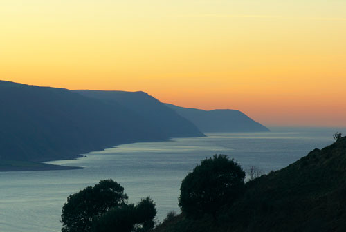 @ 1378 feet / Time 3 hours 28 minutes + breaks
OPTION – EASIER ROUTE = Less 1 mile / gentler middle section climb
OPTION – OFF-ROADING = Plus 2 miles & 700 feet / sections of challenging track
With the sea to the north and the moors to the south the paradisiac corridor, that forms to-day’s route, should once again set the tone for our holiday.
Almost entirely on quiet country lanes … this is a world of thatched cottages, dense woodlands, spectacular valleys and even the odd picture-postcard seaside village.
Although a short day in distance, there is a significant climb to negotiate mid-way!
Lynmouth is a small seaside village connected to its neighbour, Lynton, by a cliff railway and the breath-taking Glen Lyn Gorge. Between them, they have a good selection of pubs, restaurants and take-aways.
SOMERSET>DEVON
A.M. Break –Porlock (7m) / Lunch – Malsmead (16m) / End Of Ride Pub – Countisbury
ACCOMMODATION – B&B, Lynmouth
~
DAY TWO: Monday 12th – Cycle from Lynmouth to BARNSTAPLE. Distance 28 (49.5) miles / Ascent 3400 feet / Descent 3300 feet /  Zenith @ 1535 feet / Time 4 hours 20 mins + breaks
OPTION – EASIER ROUTE = Less 7 miles & 1000 feet
OPTION – VALLEY ROUTE = Plus 4.5 miles & 1000 feet
Another challenging route … that turns inland to explore the remote and exposed expanse of Exmoor.
A connection of country lanes and isolated farming communities leads to the outskirts of Barnstaple … this old harbour town is now North Devon’s largest town. The course weaves its way right through its urban and commercial heart.
Barnstaple is a vibrant place with ample facilities and things to do.
DEVON>SOMERSET>DEVON
A.M Break – Simonsbath (9m) / Lunch – Brayford (15.5m) / P.M. Break – Goodleigh (21.5m) / End Of Ride Pub – Barnstable (26.5m)
ACCOMMODATION – Motel, Barnstaple
~
DAY THREE: Tuesday 13th – Cycle from Barnstaple to BUDE. Distance 36.5 (86.0) miles / Ascent 2775 feet / Descent 2800 feet / Zenith @ 690 feet / Time 5 hours 10 minutes + breaks
A long but comparatively less arduous day.
The distance is cushioned somewhat by a piece of cycling magnificence that forms the first third of to-day’s ride … the sublime ‘Tarka Trail’ is an estuary-hugging (and blissfully flat) old railway line, transformed into a cycleway.
In order to connect two mighty bays to-day … Bideford and Bude, we tap into a network of mellow minor roads and country lanes (no nasty heavy traffic to worry about!). The area has a laid-back charm, traditional and unspoilt feel to it.
Bude has a useful range of places to eat out, the nightlife is quiet and relaxed.
DEVON>CORNWALL
A.M Break – Bideford (10m) / Lunch – Buckland Brewer (16m) / P.M. Break –Tamar Lake (28m) / End Of Ride Pub – Poughill (34m)
ACCOMMODATION – Independent Hostel, Bude
~
DAY FOUR: Wednesday 14th – Cycling from Bude to TINTAGEL. Distance 20.5 (106.5) miles / Ascent 3000 feet / Descent 2875 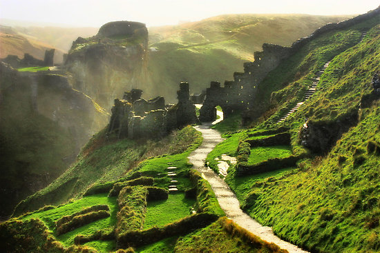 feet / Zenith @ 818 feet / Time 3 hours 17 minutes + breaks
This is the day we enjoy an afternoon on the beach … but not before a difficult sea-view fest of a ride. From dizzy clifftop heights, we plunge to sea level (and back up again!).
Tintagel is the mythical home of King Arthur and our home for the night, in one of the most spectacular locations you will ever stay in! With this in mind, I suggest we eat in the hostel (self-cook?), savour our surroundings and listen to my world-famous ‘jukebox’!
CORNWALL
A.M. Break – Widemouth Bay (4m) / Lunch – Boscastle (16m) / Afternoon At Tintagel Castle & Beach (1m from hostel via coast path)
ACCOMMODATION – YHA, Tintagel
~
DAY FIVE: Thursday 15th – Cycling from Tintagel to PAR. Distance 31.5 (138.0) miles / Ascent 3150 feet / Descent 3375 feet / 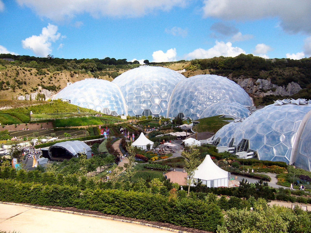 Zenith @ 699 feet / Time 4 hours 36 minutes + breaks
To get from The Atlantic to The Channel, slicing right across the county, we use minor roads, secret country lanes and (above all) a majestic stretch of cycleway … “The Camel Trail”. Brace yourself for a woodland and riverside treat (complimented with a cream tea perhaps?).
The culmination of to-day is the amazing, and surreal, experience of the Eden Project.
Par has ample facilities … should we need to stray from our pub accommodation(?)!
CORNWALL
A.M. Break – Wenfordbridge (10m) / Lunch– Dunmere (17m) / P.M. Break –Eden Project (28m) / End Of Ride Pub – N/A
ACCOMMODATION – Pub, Par
~
DAY SIX: Friday 16th – Cycling from Par to KINGSAND. Distance 31 (169.0) miles / Ascent 4900 feet / Descent 4850 feet / 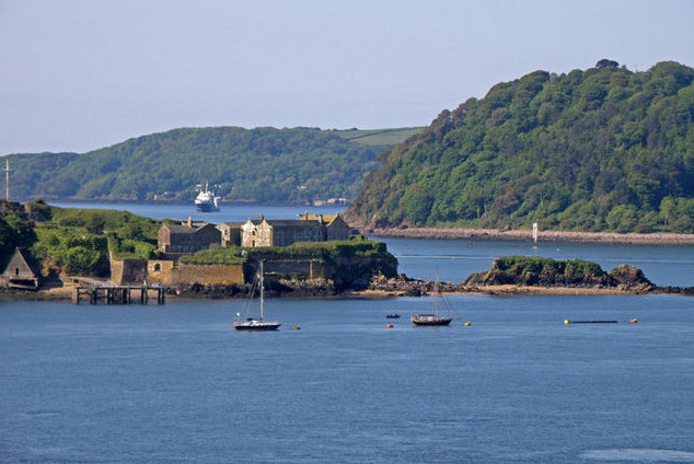 Zenith @ 505 feet / Time 4 hours 52 minutes + breaks + ferry
OPTION – EASIER ROUTE = Less 0.25 miles & 600 feet
OPTION – OFF-ROADING = Short equidistant sections of off-road
OPTION – EMERGENCY REST DAY = Train from Par to Plymouth > cycle to Kingsand via upper ferry = 5 miles
We head eastwards for the first time, on another undulating seaside treat. Our route is mostly along minor roads, as it drops in and out (and up and down!) of one majestic treasure after another.
The reward for to-day’s punishing climbs is an ocean-fest finale!
Although Kingsand has more limited facilities than previous, it is a gem of a place to stay and stare in awe over Plymouth Sound.
CORNWALL
A.M. Break – Fowey (4m) / Lunch – Looe (15m) / P.M. Break – Downderry (21m) / End Of Ride Pub – N/A
ACCOMMODATION – B&B, Kingsand
~
DAY SEVEN: Saturday 17th – Cycling from Kingsand to BELLEVER. Distance 29.5 (198.5) miles / Ascent 4250 feet / Descent 3350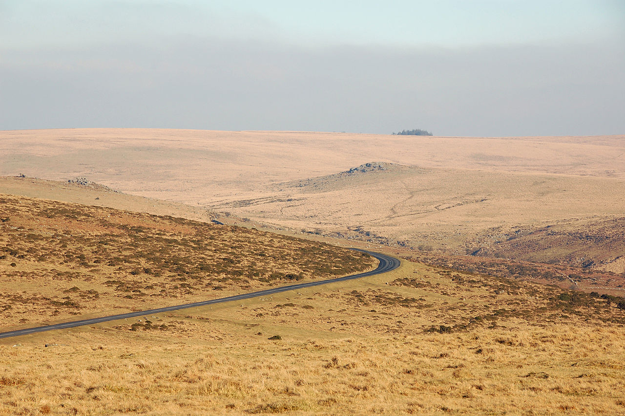 feet / Zenith @ 1409 feet / Time 4 hours 57 minutes + breaks + ferry
OPTION – EASIER ROUTE = Less 4 miles & 450 feet / avoid rough track
OPTION – OFF-ROADING = Plus 2.5 miles & 50 feet
Technically (due to the isolation) this is our most challenging day … HOWEVER, it is saturated with contrast and character!
The start is a ferry trip across one of the most remarkable stretches of water …’The Sound’.
Although there is a significant amount of climbing, it is hopefully attained steadily by tapping into the cycleway masterpiece of the Plym Valley.
We pass through Princetown (complete with its eerie Napoleonic prison!), to reach our hostel. Its remote location is set in the heart of Dartmoor … WARNING: we are now very much in “Hound of the Baskervilles” country … hope it’s not foggy!
We will need to pre-stock up with provisions and enjoy another night-in at the hostel.
CORNWALL>DEVON
A.M. Break – Plymouth (4.5m) / Lunch – Meavy (17.5m) / P.M. Break – Princetown (23.5m) / End Of Ride Pub – Two Bridges (25m)
ACCOMMODATION – YHA, Bellever
~
DAY EIGHT: Sunday 18th – Cycling from Bellever to EXETER. Distance 35 (233.5) miles / Ascent 3975 feet / Descent 4925 feet /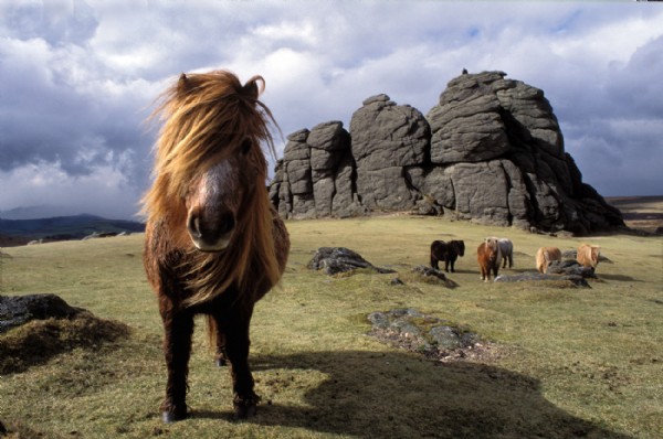 Zenith @ 1313 feet / Time 5 hours 07 minutes + breaks
OPTION – OFF-ROADING = Plus 0.5 mile & 125 feet / sections of challenging track
Although we say goodbye to the moors (and eventually to the tough climbs!), it is not before exploring another breathtaking section of this wild granite landscape.
Open roads make way for leafy lanes before we head to the finishing line by way of the waterside delights of the Exe Estuary … a fitting and savouring finale!
I hope you’ve saved some energy for the night(?) … the city of Exeter is electric!!!
DEVON
A.M. Break – Haytor Vale (9m) / Lunch – Lower Ashton (18.5m) / P.M. Break – Exminster (28m) / Musical & Celebratory Evening In Exeter
ACCOMMODATION – B&B, Exeter
~
Training Sessions:
I have put together a series of practice routes (see our separate “Cycle Routes” Page). These are intended to replicate distance, climbing and terrain, likely to be encountered. They also serve as a very useful test for your bike and gear, enabling you to iron out any snags ahead of the holiday.
They consist of easy, moderate, strenuous and even hostel stay-overs (to acclimatise you to this very unique wonderful world of budget accommodation)
 As you progress through your training regime, you will get a better idea of what kit you will require … so you might want to do some ‘retail therapy'(?). We recommend the following retailers: Chain Reaction (online) / Halfords / Decathlon.
I realise local to me might not be local to you. We have digital mapping for all of Great Britain, I will have a go at planning a route for you anywhere within, should you require(?).
~
ACTUAL STATISTICS (FOR RECORD): 8mph / ^1min / v-0.5min / round up to nearest 25/+0.5
DAY 1 = 21.3m / 3263'a / 3288'd
DAY 2 = 27.8m / 3383'a / 3290'd
DAY 3 = 36.7m / 2769'a / 2801'd
DAY 4 = 20.02m / 3004'a / 2868'd
DAY 5 = 31.13m / 3147'a / 3363'd
DAY 6 = 30.47m / 4883'a / 4827'd
DAY 7 = 29.65m / 4252'a / 3351'd
DAY 8 = 34.82m / 3973'a / 4912'd