Walk Gradings
This was set up by Chris and me some years ago. It was intended as a guide for leaders when selecting a location, and to inform them as to how our walks are categorised and the reasons why a particular area is targeted. It not only gives the distance of the walk but also the amount of climbing involved.
Terrain and pace will also be factors in determining the grade of a walk. For example … we would avoid somewhere like the northern Lakes in January, say when there is short daylight and potentially problematic weather and ground conditions. Travel times are also an important consideration. We have ventured further afield, of course. on our frequent weekend jaunts!
In these days of smartphones and apps, I hope that this information is still relevant(?).
REGIONS
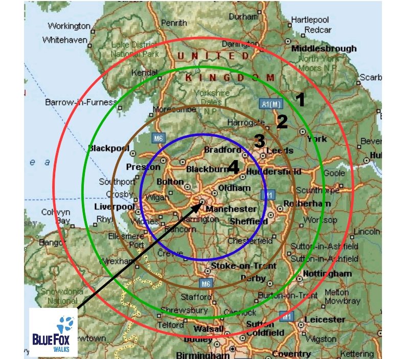
ZONE 1 = 75 miles from base June, July, August
ZONE 2 = 60 miles from base April, May, September
ZONE 3 = 45 miles from base October, November, March
ZONE 4 = 30 miles from base December, January, February
GRADES
M = Long Distance Path / Multi Day
X = Very Strenuous – over 18 miles & 3000 feet
A = Strenuous – up to 18 miles & 3000 feet
B = Moderate – up to 14 miles & 2250 feet
C = Easy – up to 10 miles & 1250 feet
H = Local/Historical Specials – up to 10 miles & flat
D = Very Easy – up to 7 miles & under 850 feet
U = Urban Special – between 4 & 8 miles
E = Disabled Friendly & ‘Tramper Trails’ – this is still in the development stage
… Outdoor Activities … Other Outdoor Activities … Other Outdoor Activities …
Nowadays just about everyone will bring some sort of gadget on a walk … that will inform them as to the EXACT distance they have travelled and how much climbing they have attained (plus a multitude of other statistical irrelevance!).
I think that this could be misleading (and off-putting) … you do not need to know EVERY single step you make upwards! The above grading figures deal with significant (and pertinent) climbing only, the distance is rounded up or down accordingly.
I too use the latest digital mapping to plan my routes, and will additionally provide precise data (in ‘English’ & Metric) for distance and ascent/descent … to appease the ‘purists’!
LIBRARY
By utilising part of our club funds, we ensure that we have an up-to-date map and guidebook collection that ‘Waterstones’ would be proud of!!! It includes …
1:25000 ‘O/S’ maps (in paper & LICENCED digital format), 1:40,000 ‘Harveys’ maps / 1:50000 ‘O/S’ maps (LICENCED digital format) / 1:10000 ‘Streetmap’ for urban areas (LICENCED digital format) and the SUPERB ‘Alan Godfrey’ historical maps for our ENTIRE local area.
 I have catalogued (and will continue to do so) all the ‘best’ walks from my huge backlog of ‘Trail’ magazines. They are very useful ‘fillers’ and tend to be ideal for our purposes.
You are all more than welcome to tap into our ‘library’.