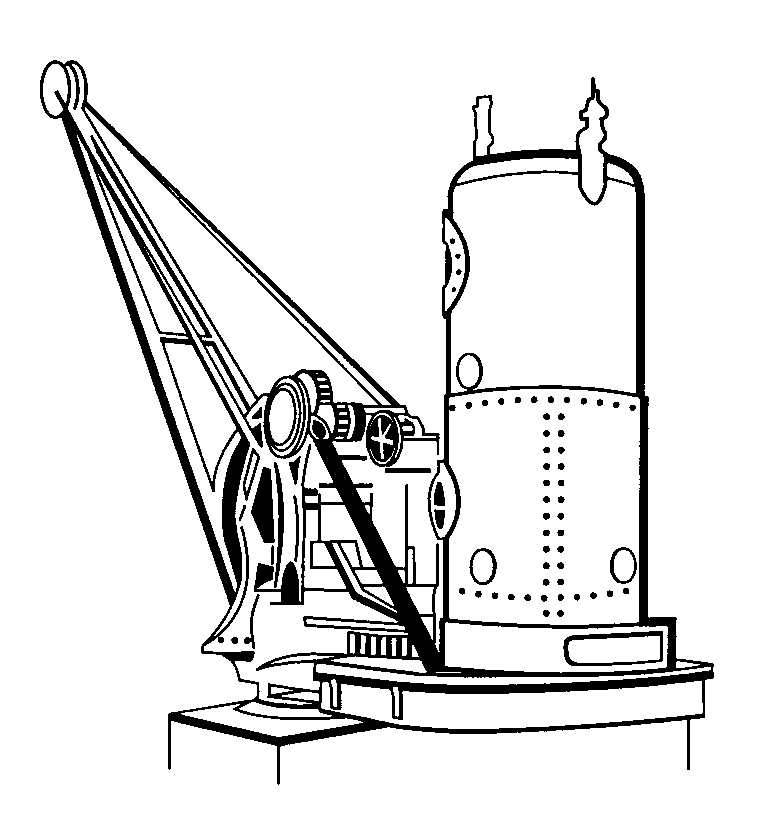
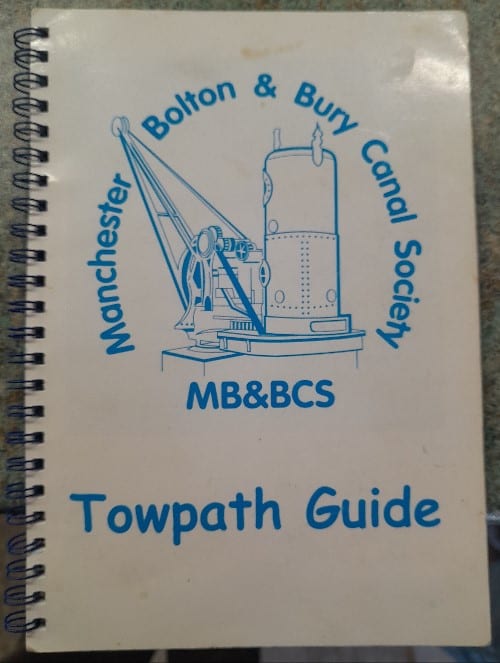
Manchester, Bolton & Bury Canal
The Manchester Bolton & Bury Canal was built between 1791 and 1808 at a cost of £127,700.
~
This was one of the very first Blue Fox projects that evolved into a wonderful and fun series of successful group walks.
My initial interest in the M,B&BC arose from reading Paul Hindle’s exhaustive book. My slant was to break down the canal’s entire journey into sections and subsequently produce a series of manageable walks. Manageable … measured not just by distance, but by content volume (to avoid information overload!).
Although the canal was the star of the show, I left much of the technical bits to Paul’s book but put my own twist on the story by encompassing a wealth of points of interest that surround the canal’s route.
I had the privilege chance meeting with Fred Dibnah (President of the M,B&BC Society) in the early 2000s at the Horseshoe Pub, Ringley. He was very optimistic about the canal’s restoration, citing that a multi-thousand pound feasibility study had been made and the dream was on!
Alas, the canal is still derelict, but PHENOMENAL strides have been made to completely upgrade the towpaths and undergo essential maintenance … complete testimony to the tireless efforts by the team of volunteers of the Society.
Armed with an inordinate amount of fresh reading and research, I have revisited the scene. Again, I come from a walking angle … attempting to unravel the canal’s fascinating and complex story in a logical, seamless and enjoyable manner(?).
My thanks to Jon for his company along the way and for his invaluable contribution to this local story. There are no plans to resurrect group walks, we have started the long process of producing a series of videos to complement our research (see foot).


~
~
HISTORY TIMELINE
1789
The original plan for the Manchester, Bolton & Bury Canal was to create a link on which goods from both Bolton and Bury could be carried to the growing city of Manchester. It was planned to be a narrow canal which would run from the centre of Manchester to a point between both Bolton and Bury. It would then split into two arms which would run separately into each of the towns.
To reach central Manchester the route needed to meet the Mersey & Irwell Navigation (River Irwell), but all canal companies which had come anywhere near this waterway in the past had done their best to avoid it!
In order to navigate the Irwell, an extortionate toll was charged by the M&IN … it saw the canals as a major threat to its future existence. Because of this, the proprietors of the M,B&BC decided to do as the Bridgewater Canal had done nearly 30 years earlier and build an aqueduct across the river, thus avoiding it all together.
1790
To the north west of Bolton work had re-started on the flagging the canal which, if completed, would be the first route to cross the Pennines. The M,B&BC projectors realised their proposed canal was ideally placed to create a lucrative link between Manchester and the Leeds & Liverpool Canal.
Thus, they changed their plans and decided to build the M,B&BC broad and extend it past Bolton to meet the Leeds & Liverpool Canal near Wigan. It is probably because of the extra cost involved in creating a longer route and making it broad that plans to build an aqueduct over the Mersey & Irwell Navigation were dropped.
Instead the company decided to suffer the river navigation’s high tolls and build a junction onto the River Irwell in central Manchester.
1791
The canal’s Act of Parliament was passed and work began but the history books concentrate less on the building of the canal and a lot more on the politics surrounding it and its neighbouring canals …
1792
A separate canal was being planned which would provide a new trans-Pennine route and would run directly into Manchester via Rochdale. This meant the M,B&BC would not gain from building a link to the Leeds & Liverpool Canal, so the decision to cancel the line from Bolton to Wigan was made, the MB&BC would now end in Bolton. This prompted the promoters of the Lancaster Canal to seriously think about linking their canal (which was also just getting under way) to Bolton, giving them a direct link to Manchester. Their alternative was to build a line from Wigan to Liverpool but in the end no decision was made and no link was made to Bolton.
1803
The Leeds & Liverpool Canal proposed a line from Wigan to Leigh where they would join the Bridgewater Canal and connect Liverpool to Manchester. The M,B&BC fought this proposal hard, if a connection was to be made they wanted it to go via their canal (which was still under construction). The Bridgewater Canal was equally keen to stop the link being made as it already had its own route to Liverpool on the south side of the Mersey. The Bridgewater Canal won the day and no link was created … much to the relief of the Manchester, Bolton & Bury company.
1808 – Fletcher’s Canal
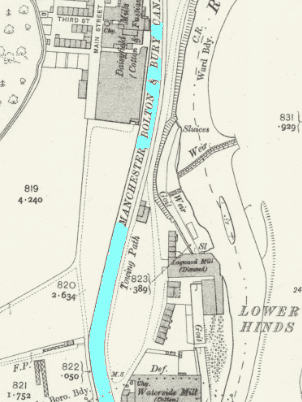
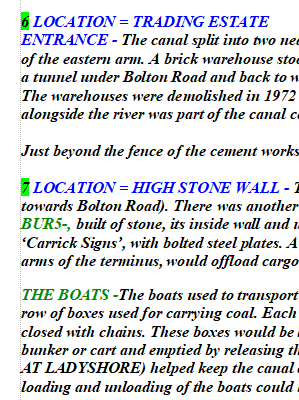
The M,B&BC opened throughout, from the centre of Manchester to the centres of both Bolton and Bury. It was 16 miles long with 3 aqueducts, 17 broad locks and was fed by a reservoir near Bury. Just south of Clifton Aqueduct (where the canal crossed the unnavigable River Irwell near Clifton village) a private canal joined the M,B&BC. This was named Fletcher’s Canal, after Matthew Fletcher who was a local colliery owner. The route of this new canal was not a totally new one however as it had been developed by James Brindley even before the days of the Bridgewater Canal. Brindley had designed it as a water drainage channel for the suitably named Wet Earth Colliery.
1812
After four years of use the Manchester, Bolton & Bury Company were able to pay out its first modest dividends. The main cargoes being carried included coal, stone and groceries, there were also passenger services from Bolton and Bury to Manchester with a return fare costing 2s 6d. Passengers would change boats at Prestolee to avoid delays at the lock flight there. Another passenger service ran along the two arms from Bolton to Bury and over 60,000 passengers per year travelled on the canal. The service was quite luxurious compared to some packet boat services, central heating was provided in winter and drinks were served on board. However, this caused a tragedy in 1818 when a party of drunken passengers managed to capsize the boat … number of passengers, including two children, were drowned!
1831
The company was quick to see the potential of railways, as Manchester had already become the first place in the world to run a railway passenger service. It successfully obtained the right to build a railway of its own between Manchester and Bolton and the company changed its name to became the “Manchester, Bolton & Bury Canal Navigation and Railway Company”! Soon, after this a new committee was formed of which the majority of men had railway interests. At first they planned to close the canal and build tracks on its bed but for some (unreported) reason they eventually built the railway alongside the waterway and actually improved the canal while the railway was being built.
1838
The railway line opened and immediately began to carry passengers bringing to an end the canal’s own passenger service.
1839
The Manchester & Salford Junction Canal opened in the centre of Manchester. It was just one mile long and was built primarily to allow Rochdale Canal traffic to reach the River Irwell (and then the Mersey) without having to travel on the Bridgewater Canal. Its junction on the River Irwell was also very close to the entrance of the M,B&BC which meant its traffic could now reach the centre of Manchester without having to use the Mersey & Irwell Navigation.
1842
Much to the dismay of the M,B&BC, the Manchester & Salford Junction Canal was bought out by the Mersey & Irwell Navigation company. This meant that, once again, boats travelling into central Manchester had to pay the extortionist tolls charged by the river navigation. However, just three years later, in an era of take-overs and amalgamations, the neighbouring Bridgewater Canal Company bought the Mersey & Irwell Navigation and problems were eased somewhat.
1846
The M,B&BC & Railway Company itself amalgamated with the Manchester & Leeds Railway Company which within a year became the Lancashire & Yorkshire Railway Company. Unlike a lot of other waterways, the M,B&BC was not closed down by the railway or left to run into disuse. On the contrary, it was well maintained and continued to be well used even though the railway line was running successfully alongside it!
1880
Damage caused by subsidence led the canal’s owners to rebuild sections of the route. In the long run this proved to be a big bonus because the subsidence problems had cost the company a lot of money over the years. Following the repairs maintenance costs on the trouble sections were greatly reduced. Revenue was also gained at this time by selling water to local businesses which otherwise ran straight into the River Irwell.
1920s
After almost 120 years of success the M,B&BC finally began to hit hard times. New damage from mining subsidence and the closure of a number of local pits resulted in loss of trade and a big drop in revenue for the waterway. The pit closures also hit Fletcher’s Canal when the colliery that it served closed in 1928. Pilkington Tile Company, which was situated on the branch’s southern bank, took control and used it for a number of years.
1935
The Pilkington Tile Company gave up using Fletcher’s Canal and the short waterway was closed.
1936
A breach occurred just ½ a mile into the Bury Arm. The damage was never repaired and Bury was cut off from the rest of the route, although the arm itself was still used as a self contained canal.
1941
London Midland & Scottish Railways (who now owned the canal) abandoned seven miles of the waterway including the whole of the arm to Bolton. The closures left the canal in two separate parts, neither of which were connected to any other waterway.
1961
The remaining sections of the canal (which were now owned by the government) were also abandoned. On many canals up and down the country, abandonment came after decades without seeing a boat but the M,B&BC actually continued to carry a small amount of traffic even after the official abandonment.
1968
Finally, the last boat to use the canal was moored for the last time. It had been carrying coal on a 100 yard stretch of the waterway from a dump to a works in Bury.
1994
In a magazine article in December it was reported that the locks on the Prestolee flight near Nob End Junction had been cleared (allegedly) of trees and weeds. The article also reported that the canal’s restoration society had leased the old canal side buildings at Nob End from British Waterways at a nominal rent. These were to be restored and used as the society’s headquarters. On the Bury Arm an area to the east of the breach of 1936 was cleared, dredged and fully restored as a linear park.
1995
It was reported that the society had lodged a £3.5 million application for restoration of the Bolton and Bury arms, the Prestolee Locks and the canal side buildings at Nob End Junction. To succeed, the application needed a matching sum of money from local authorities and BW. No further reports were made on the outcome of the application. The restoration society hoped to fully restore the Bolton and Bury arms by the year 2000.
1997
Between the locks at Prestolee and the newly restored sections of the Bury Arm, at the site of the 1936 breach, the line of the canal was now owned by Danisco Paper company. A factory building stands right across the canal bed and will provide a major obstacle to restoration. However, Danisco Paper have offered to sell their section of the canal to the restoration society. No big fund raising campaign was needed to make this purchase … the price was just £1.
In December the Waterway Recovery Group arrived at Prestolee Locks and this time they really did clear the chambers and surrounding area of shrubs and other overgrown plant life. For the first time in many years the three-way junction could be clearly seen. However, restoration of this section to a navigable state is still some way off, and the opening of the whole route will take many more years.
~

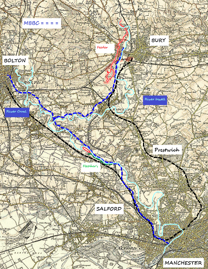
WALK 1 ~ BURY TO RADCLIFFE ~ 5 MILES (Bury > Radcliffe Tram Stations)
WALK 2 ~ FEEDER & ELTON RESERVOIR ~ 8 MILES (Bury Tram Station circular)
WALK 3 ~ RADCLIFFE TO CLIFTON ~ 8 MILES (Radcliffe > Prestwich Tram Stations)
WALK 4 ~ FLETCHER’S CANAL & WET EARTH COLLIERY ~ 8 MILES (Radcliffe > Prestwich Tram Stations)
WALK 5 ~ NOB END TO BOLTON ~ 6 MILES (Moses Gate > Bolton Railway Stations)
WALK 6 ~ CLIFTON TO MIDDLEWOOD ~ 8 MILES (Prestwich > Deansgate Tram Stations)
WALK 7 ~ MANCHESTER CENTRAL ~ 3 MILES (Deansgate Tram Station circular)
~
This project goes into incredible detail … far too much content for this site to facilitate, (hence our future plans for videos), but here is a taster.
Much of the canal no longer exists and its course is far from obvious in places. Using contemporary paths, these walks set about to link the present with the past and the the future and to demonstrate how its entirety can be followed.
~
Part I … Bury to Radcliffe

This walk delves us into an obscure and forgotten part of Bury, it sets the tone … to expect the unexpected! Our route slices through the streets of Elton, still visibly rich in its industrial past, before magically meeting the canal for the first time. A very pleasant stroll ensues all the way to Radcliffe. It epitomizes what a great local asset the resurfaced towpath is, for ALL to enjoy.
~
Part II … The Feeder

This walk starts in earnest deep inside Burrs Country Park, to explain the pivotal role of The Feeder. Much of the 2.5-mile channel of water (the feeder) is on private land, therefore we are unable to follow it faithfully. Instead, a weaving course is required, affording a series of tantalising glimpses of this long- forgotten engineering marvel.
~
Part III … Radcliffe to Clifton
This walk picks up the thread by way of a return to Radcliffe. The section is without doubt the most scenic, particularly as it joins company with the River Irwell, along a carpet of cobbled beauty. The Prestolee Hub, complete with the remains of its ladder of locks, makes its debut here. From Ringley, the course becomes less obvious … as the urban wilderness returns!
~
Part IV … Fletcher’s Branch
This walk is the shortest stretch of canal that we have hitherto explored, but perhaps the most complex … it is a jumble of historical layers. Before we can understand the story of Fletcher’s Canal, we need to uncover the story of Wet Earth Colliery … and its remarkable legacy to industrial history. The views down the Irwell Valley are amongst the finest in the entire area.
~
Part V … Prestolee to Bolton

This walk is the most difficult to follow, as much of the latter part is either secluded or completely obliterated. It starts straight-forward enough with a pleasant tootle through Moses Country Park and alongside the River Croal. From Prestolee, the initial stretch of the canal and towpath is in a fantastic state of preserve … a privilege to witness. Hereon, we lose the scent but gain an intriguing sense of exploration.
~
Part VI … Clifton to Middlewood
This walk reveals how the canal made its way to the outskirts of the city, competing with the new kid on the block … the railway .. on the way. It starts with a long stretch of waterway magic … much has mercifully survived. As it slices through Salford, our luck runs out with regard to visual evidence, that is until the final leg. Middlewood was restored in 2008 and is a demonstration of future intentions for the canal.
~
Part VII … Manchester Central
This walk is comparatively short, but no less absorbing as it solves the last piece of the jigsaw … our canal journey ingeniously reaches the heart of the industrial leviathan of Manchester and the wider canal network. With the railways already on the scene (born in this very city), the route follows a twin thread … one inconspicuous and the other subterranean(?).
~
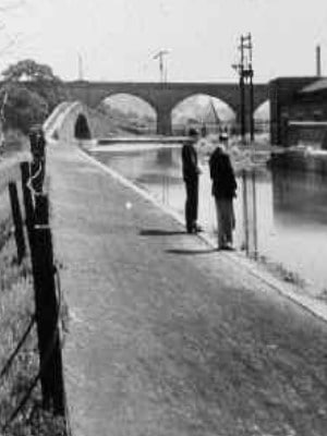
The template I used to afford me a smooth, interesting and informative walk was to arm myself with four walk-friendly paperwork tools … an O/S Map (a mix of Streetmap and Explorer) > historical map with easy locating reference > points of interest (updated annually) that can be linked to the map > old pictures (much of the canal and its gems no longer exist, so a visual representation is an ideal way to portray the story).
~
..THE FUTURE … THE FUTURE … THE FUTURE … THE FUTURE …
The MB&BC Society was formed in 1987 with the intention of restoring the entire canal’s route so that it can be used for leisure and contribute to local regeneration.
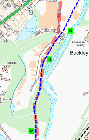
Earlier studies from 1996 and 2004 addressed the full restoration dream, whereas a further feasibility study in 2021 focused on an approximately five-mile stretch from Wellington Street in Bury, through Radcliffe, to Hall Lane Basin at Little Lever. Although there are a couple of significant hurdles to overcome at Water Street, Radcliffe and the ‘breach’ near Nob End, there are no locks to contend with and much of the length is already in water. The new housing estate being built on the old Creams Paper Mill site, will bring part of the canal back into use, with woodland and waterside walks for residents to enjoy.
At the Salford/Manchester end, some progress has eventually been made around Middlewood … the vision of a mixture of housing, retail and commercial has begun to be realised … part of a much-needed redevelopment injection masterplan for this area.
~
~
ACKNOWLEDGEMENTS: Nigel Hardacre / Dave Arnold / Darcy Lever Gravel Pits Action Group (GPAG) / Gale Blackburn