Northumberland Cycle Round (TBA)
Originally planned for 2015, I am afraid that this one was scuppered as a group holiday. In February 2015 the YHA at Keilder closed, this was to be our strategic start and finish point. It is an absolute shame that somewhere in as magical a location as here could not attract enough “customers” and the decision was taken not to renew the licence with the local council landlord. I feel it is a sad testament to our time … hostels seem to be closing at a faster rate than country pubs!
I am however convinced that something will come of the vacant building in the form of budget accommodation (maybe an independent hostel?), as the economy picks up. For this reason, I am going to leave the route in place hopefully for future use. There is an alternative start and finish point possible just south of Keilder by the way(???).
I have put an incredible amount of work into this and sincerely hope that I will be able to complete it in the future. It seems too good to waste and is available for anyone to make use of … all that is required for full completion of the ‘paperwork’ is accommodation details.
I can not remember working on such a diverse area, it can be sub-divided thus: Forests & Reservoirs / Mountains & Valleys / Castles & Islands / Rivers & Country Estates.
This was the plan! …
~
Introduction:
 Northumberland Round 20xx (N 0 R)
Northumberland has to be the last truly wild and unspoilt part of England(?). I have once again drawn on my knowledge of the area to suggest it as this year’s cycling holiday offering. Chris and I produced a big walking show up here some year’s ago … we spent many an hour travelling up and down ‘The Great North Road’ to our base at Alnwick undertaking our reconnoitre duties! I have also enjoyed a couple of family holidays here so I know what beautiful coastal riches it has. My third (and extremely happy) recollection is watching the RAC Lombard Rally in the massive Keilder Forest in pitch blackness … I always promised myself a return.
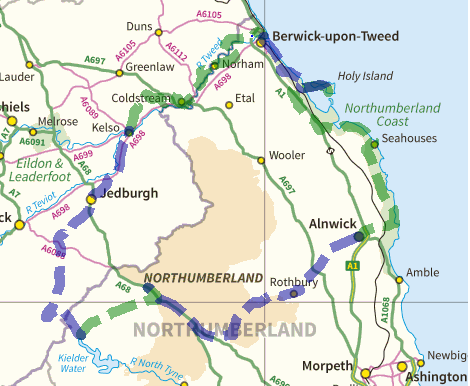
Logistically it is (comparatively) very simple to arrange … although the cycling is pretty much in line with the other holidays. What I mean is that because it is a circular you can arrange your own transport. Also, the national park is well served with youth hostels … making this a more budget-friendly option. Traditionally I have selected May, but I am aware that we are that much further north and summer will not have fully kicked in (on the C2C we had snow in Swaledale!). Therefore September should be preferable(?) … possibly even August, as there are not the constraints (in this quiet part of the world) as say Devon & Cornwall during school holidays.
~
~
I have outlined the following below: Costings / Statistics / Itinerary / Training Routes / see also our “Cycling Holidays” Page, for additional information …Vinnie
~
Costings:
(Manchester based): Own Transport (Fuel) = £60.00 per car Accommodation + All Food (breakfast, packed lunch and evening meal) = approx. £XXX.00pp Toll Roads (???) = £xx.00 Ferry Crossing = TOTAL = £ To try and draw some parallels .. the C2C TOTAL was a bargain £380pp and the B2B was £405pp (we did get an extra day). I assure you, we didn’t exactly slum it! … ALL our accommodation was first class and our evening meals hearty and of high quality. I did need another 400 quid for beer mind you!!!~
Statistics:
To give you a statistical comparison, we completed … C2C in 6 days / 168 miles / 15324 feet of climbing (if the extra leg, that Jon and I did, is included then 7 Days / 189 miles / 17071 feet) B2B in 7 days / 207 miles / 16705 feet of climbing NoR in 5.5 days / 162 miles / 12650 feet of climbing| C2C
Prestwich to St Bees 128 miles Keswick 27.5 miles / 3010 feet Patterdale 15.6 miles / 2182 feet Kirkby Stephen 30.5 miles / 2537 feet Richmond 33.7 miles / 3566 feet Great Broughton 29.8 miles / 877 feet Whitby 30.3 miles / 3152 feet Scarborough 21.0 miles / 1747 feet Whitby to Prestwich 117 miles
|
B2B
Prestwich to Chepstow 181 miles Ross on Wye 31.1 miles / 3453 feet Leominster 29.8 miles / 2142 feet Bridges 35.0 miles / 3956 feet Ellesmere 31.7 miles / 1444 feet Llangollen 22.9 miles / 1815 feet Ruthin 21.1 miles / 2854 feet Llandudno 35.2 miles / 1041 feet Llandudno to Prestwich 89 miles
|
| NoR
Prestwich to Keilder 157 miles Kelso 36.5 miles / 3050 feet Berwick on Tweed 32 miles / 1850 feet Holy Island 14.5 miles / 600 feet Alnwick 38.5 miles / 2250 feet Byrness 36.5 miles / 3500 feet Keilder 14 miles / 1400 feet Keilder to Prestwich 157 miles |
C2C = 28m + 2554′ / B2B = 29.5m + 2386′ / NoR = 27m + 2108′
FEET OF CLIMBING PER MILE:
C2C = 91′ per m / B2B = 81′ per m / NoR = 78′ per m
~
Itinerary:
ARRIVAL DAY: xxxx – Travel by car to start point (155 miles = XXX hours + 30 mins break)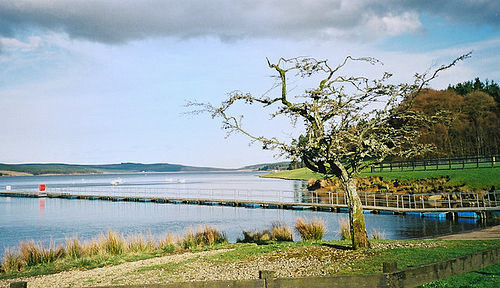
My intention is to get here early enough to explore this magnificent and unique part of the world! I have come up with several options:
- Cycling (luggage-free) around the mighty Keilder Water (reservoir) … the largest man-made lake in northern Europe!
OPTIONS – PART OFF-ROADING = 15.25 or 10.5 miles / A&D 1775 or 1220 feet (plus a ferry crossing in the middle!)
- Various water activities (canoeing / rowing-boating / sailing) – www.visitkeilder.com/play/adventure/water-activities
- Keilder Observatory – this award-winning site is a 2-mile cycle ride away via Vampire Forest (not sure why it’s called that???) – www.keilderobservatory.org
- Birds of Prey Centre / Indoor heated swimming pool
ACCOMMODATION – YHA, Keilder £18 shared / £39 private
~
DAY ONE: xxxx – Cycle from Keilder to KELSO. Distance 36.5 (36.5) miles / Ascent 3050 feet / Descent 3550 feet / Zenith @ Rushy Rig 1215 feet / Time X hours XX minutes + breaks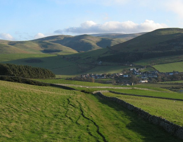
This is a challenging opening day, as we skirt around the mighty Cheviots. Deep valleys and remote mountain passes will eventually give way to the gentler terrain of the Border country.
Kelso is
ACCOMMODATION – Kelso £35 shared / £55 private
~
DAY TWO: xxxx – Cycle from Kelso to BERWICK on TWEED. Distance 32 (58.5) miles / Ascent 1850 feet / Descent 1850 feet /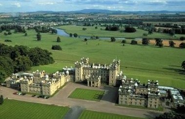 Zenith @ Wormerlaw 205 feet / Time X hours XX minutes + breaks
A more gentle day in-store, set amidst the Scottish Borders. We follow the course of the mighty River Tweed as it heads east towards the sea. One magnificent stately home after another should nicely distract our attention and keep us reaching for our cameras (and a rare opportunity to see how the poor people live!).
exploring the dark history and ancient abbey towns
Berwick on Tweed
ACCOMMODATION – Berwick £16 shared / £29 private
~
DAY THREE: xxxx – Cycle from Berwick on Tweed to HOLY ISLAND. Distance 14.5 (73) miles / Ascent 600 feet / Descent 650 feet / 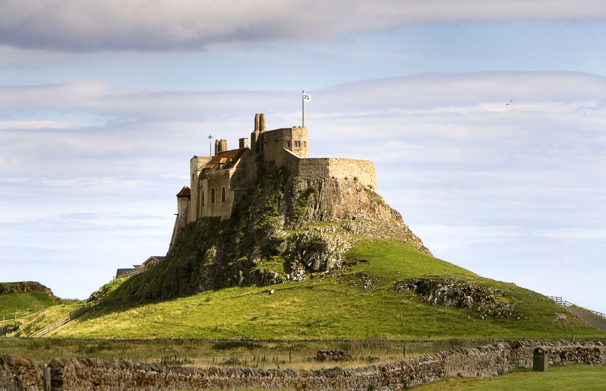 Zenith @ Redshin Cove 105 feet / Time X hours XX minutes + breaks
An extremely relaxed and easy seaside ride to the incredible island of Lindisfarne. We will be dictated by the access to the causeway, but I envisage us getting there as soon as we can and enjoying our time sightseeing or paddling in the sea!
Lindisfarne is
CAUSEWAY SAFE CROSSING: 08:50 to 15:20 (allow 1/2 hour either side)
ACCOMMODATION – Holy Island £100 room
~
DAY FOUR: xxxx – Cycle from Holy Island to ALNWICK. Distance 38.5 (111.5) miles / Ascent 2250 feet / Descent 2100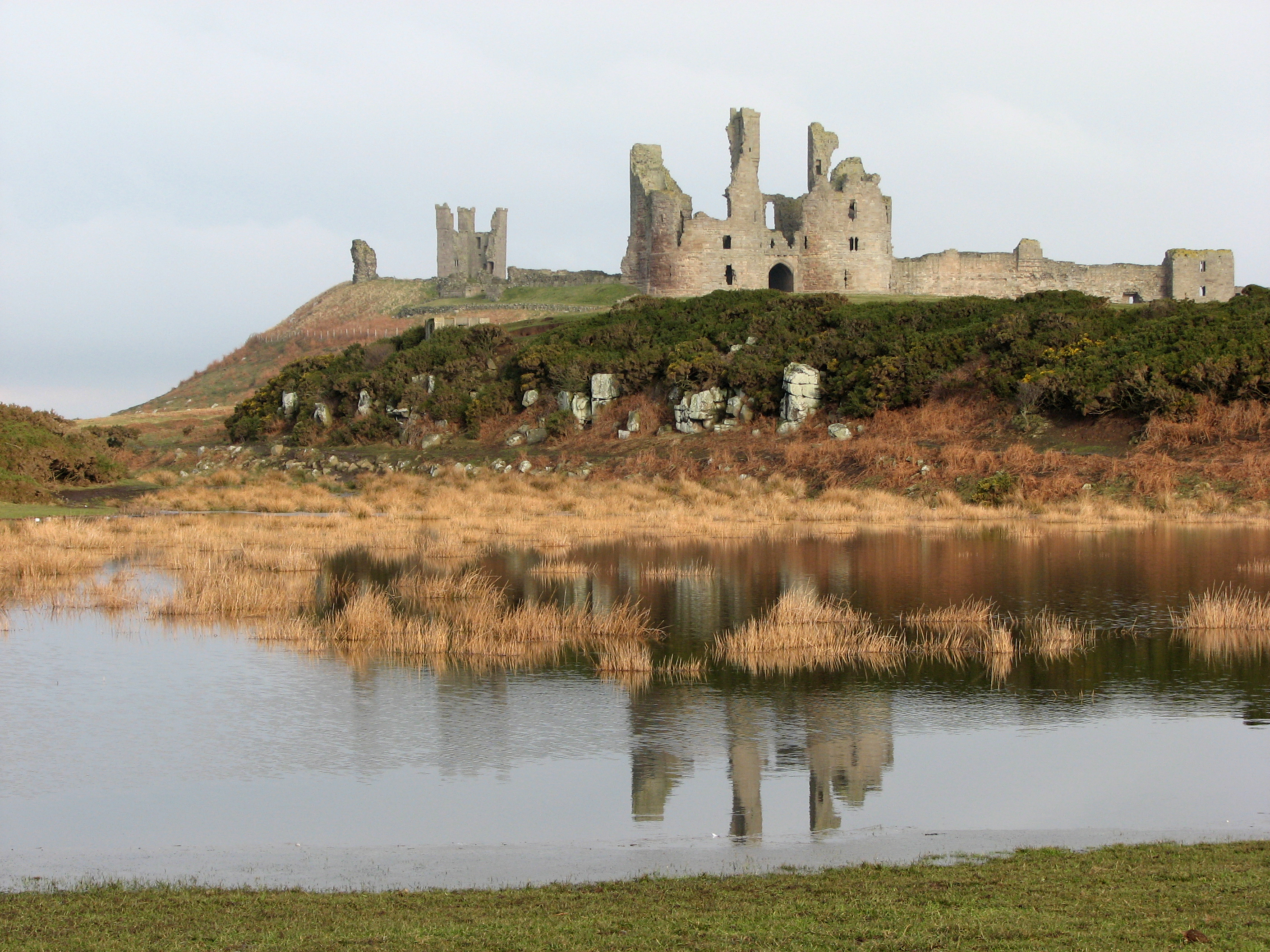 feet / Zenith @ Longlee 355 feet / Time X hours XX minutes + breaks
CAUSEWAY SAFE CROSSING: 09:15 to 15:55 (allow 1/2 hour either side)
A long day but a coastal hugging treat. This promises to show the very best of the county (and the country) along quiet country lanes and cycleways, interrupted by a host of seaside places and castles.
Alnwick is
ACCOMMODATION – YHA, Alnwick £20 shared
~
DAY FIVE: Friday 18th – Cycle from Alnwick to BYRNESS. Distance 36.5 (148) miles / Ascent 3500 feet / Descent 3000 feet / Zenith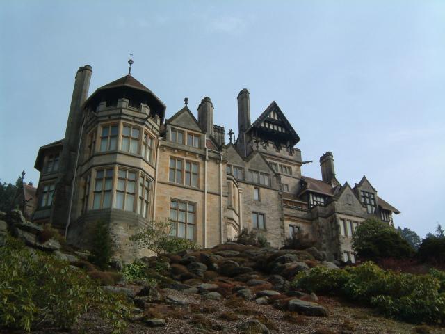 @ Gowk Hill 905 feet / Time X hours XX minutes + breaks
This long challenging day will take us back into the heart of the national park. A blend of vast forests and long riverside roads.
Byrness is a tiny hamlet … this is our relaxing ‘night in’ at our hostel, enjoying a glass or two of celebration sherry and listening to music provided by that world-renowned talent … DJ Fox.
ACCOMMODATION – YHA, Byrness £
~
DAY SIX: xxxx – Cycle from Byrness to KEILDER. Distance 14 (162) miles / Ascent 1400 feet / Descent 1500 feet / Zenith  @ Blakehope Nick 1492 feet / Time X hours XX minutes + breaks
We end our adventure with a slice of mischief! (no looking at the map). We take in one of the highest roads in England, with BREATHTAKING views to match.
~
Training Sessions:
I have put together a series of practice routes (see our separate “Cycle Routes” Page). These are intended to replicate distance, climbing and terrain, likely to be encountered. They also serve as a very useful test for your bike and gear, enabling you to iron out any snags ahead of the holiday.
They consist of easy, moderate, strenuous and even hostel stay-overs (to acclimatise you to this very unique wonderful world of budget accommodation)
 As you progress through your training regime, you will get a better idea of what kit you will require … so you might want to do some ‘retail therapy'(?). We recommend the following retailers: Chain Reaction (online) / Halfords / Decathlon.
I realise local to me might not be local to you. We have digital mapping for all of Great Britain, I will have a go at planning a route for you anywhere within, should you require(?).