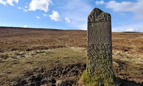
Lyke Wake Walk
The Lyke Wake Walk is a 40-mile challenge walk across the highest and widest part of the North York Moors. The walk remembers the many corpses carried over the moors on old coffin routes and the ancient burial mounds encountered on the way … the name derives from a ‘lyke’, the corpse and the ‘wake’ watching over the deceased. Its associated club has a social structure, culture and rituals on the walk and Christian and folklore traditions from the area which it passes.
The idea of a walk originated from an article in the ‘Dalesman’ magazine in August 1955. Its author, Bill Cowley, described a 40 mile walk across the NY Moors from east to west (or vice versa) on heather all the way except for crossing one or two roads. Given the remoteness of the area, a lone walker might not encounter another during the one to two day journey. Cowley issued a challenge to see if anyone could walk from Scarth Wood Moor at the western extremity of the moors to Ravenscar on the coast, keeping on or close to the main watershed of the moorland, in a 24-hour period. The first crossing was completed shortly afterwards on the 1st and 2nd of October 1955. Cowley was in the party that made the crossing in 23 hours and he wrote a book … “Lyke Wake Walk”, which he kept up to date by frequent revision, running to 12 editions in the author’s lifetime. It was revised in 2001 by Paul Sherwood.
Jon and I first took up this challenge in 2005. Enduring searing heat and with FULL backpacks, we battled on for 25.5 solitary hours to the end … although outside the official temporal target, I did not see it as a failure.
We returned in 2023 and completed the task in just over 21 hours. There was one essential difference … this time, Jon took up the role of our support team. This enabled a newly assembled group to travel as lightly as possible and have the security of knowing help was on hand in an emergency.
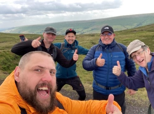
THE 2023 TEAM (“DIRGERS”) … myself (VA), Mark (Mr Steadfast) and the Latvian dynamic duo of Mareks and Gatis .. a huge congratulations.
THE WALK … prudence steers any prospectors to a west >>> east approach. This is to take advantage of prevailing winds and the heather lying away from the walker. Date of execution is another factor, as close to the summer solstice as possible … daylight is a premium!
There is no exact route, but successful crossings must stick to moorland summits as far as practicable.
A traverse of the LWW passage is referred to as a ‘crossing’ and the act of participating in the walk is known as ‘dirging’.
THE NEGATIVES … this wonderful concept is not without its controversies and downsides. With hoards of eager adventurers attempting the odyssey over the years, and with no set route over its course, erosion has taken its toll. Disturbance to game birds, sheep and other wildlife and the potential intrusion at remote farms by walkers and their support parties at all times of day and night, are unacceptable prices to pay. Indeed, the Ordnance Survey no longer marks the walk route on its maps at the recommendation of the National Park Authority as a measure to discourage large numbers. The walk has not been mentioned in any Authority publications for a number of years.
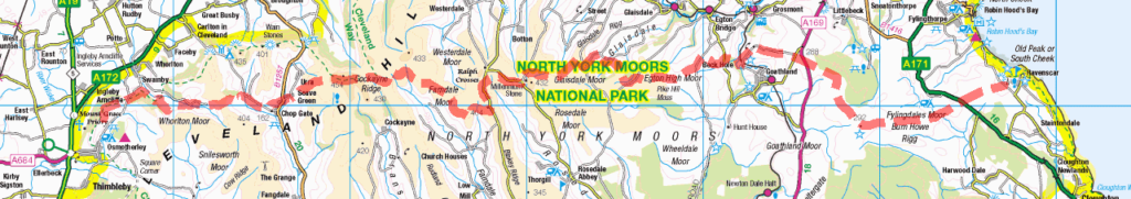
OUR CONTENTIOUS (43 MILE) ROUTE … AN ALTERNATIVE PIONEERING SOLUTION(?). For practical purposes, we used the masts at Scarth Moor, Osmotherley and Stony Marl Moor, Ravenscar as our start and finish points.
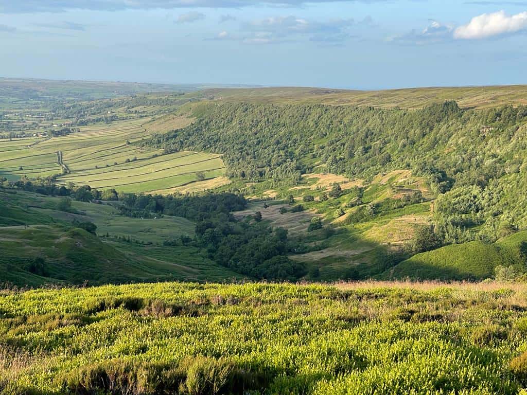
We excitedly eased our way into our adventure by conventionally following the Cleveland Way. At Swine Park, we left the national trail and made a direct strike towards the foot of Urra Moor. With fresh legs and mouth-watering views to accompany us all the way, the hours and miles soon melted away. Round Hill on Urra Moor symbolised the highest point on the LWW … it was reassuring to achieve it so early on.
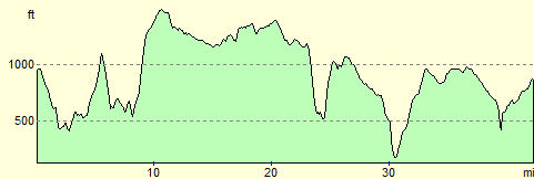
The remote and very long winding track, which was once a railway line built for transporting ironstone, makes for a very easy section (although, I reckon that it could be quite daunting in inclement weather). It was an opportunity to cover some ‘cheap’ distance.
Our next tick-off destination was the iconic Lion pub at Blakey Ridge. This was where our essential backup crew (namely Jon!) was based. Crews can either camp (extremely basic and exposed), campervan or book a room at the pub. There were no facilities to afford us, who were just passing through, a much-needed brush and clean-up, but it was at least a chance to change our kit. We treated ourselves to a lengthy relaxation here and tucked into a hearty meal.
With evening well upon us and dusk approaching, the next few hours were absolutely critical. Hereon, there was no margin for error whatsoever and no Plan B available to us. To rely on Rights of Way (either official footpaths or bridleways) would have been suicide and wholly foolhardy in my opinion … I have the upmost respect for the early pioneers of the LWW, but my modern, eco-aware, conscious could not allow us to blindly tackle waist-deep heather (I didn’t fancy encountering the many REAL threat of snakes, ticks and other beasties that have made their home in the undergrowth anyway!).
My tactic was simple, but incredibly effective …. to knit together a series of empty open roads and well-defined tracks that ingeniously cross the Open Access moors with regular reliability.
The intention was to have a prolonged rest, and maybe catch forty winks, at Wintergill. However, it proved far too cold and windy to glean anything that remotely resembled a comfortable kip.
Now, here’s the catch … in order to achieve my ‘green’ objective, we had to veer slightly more north than normal convention. I was fully aware that we could have breached the ‘rules’ …”…walkers straying into Eskdale are disqualified..”, but I am proud to have stuck to my principles and I was even prouder of my route … it was an unblemished success.
Night-time was well and truly on us. We headed for the charming oasis of Beck Hole, where I knew some luxurious wooden benches and an extended sheltered break awaited! Before we reached this spot, and to prove that immense fun can still be had, we negotiated the dense woodland around Murk Esk Cottage. The torch-illuminated path we now followed would have been a piece of cake to negotiate in daylight … but it was pitch-black for us. It proved to be a memorable hoot (owl connection!) and somehow relieved whatever tensions had existed … only I in the party had ever seriously walked at night before.
More mundane road, before reaching Sneaton High Moor. Although the sun was due to rise, the mood definitely had taken on a less verbose tone. We were all getting tired and the sleep deprivation was beginning to take its toll. Even the hitherto silky smooth trackways had turned into a boggy and rutted drudge. Small topographical features in the distance suddenly seemed to take an eternity to reach. We needed a tonic … we got it in the landmark of Fylingdales RAF base, it seemed close enough to touch.
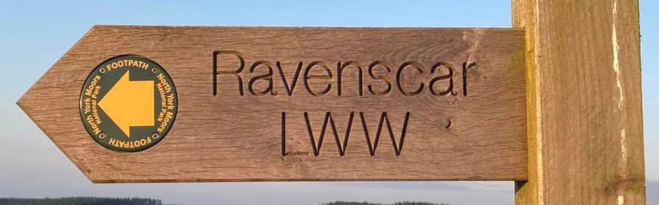
The last six painful miles now lay ahead, as we headed due east to cross the comparative walker-highway of Fylingdale Moor. I am not sure that being able to see our finishing line (the mast at Ravenscar) way in the distance was a good thing or not, our eye line was fixed in an acute upward direction onto the mast … we realised this meant a serious climb was in store!
Renewed energy was required as we plunged into the beauty spot of Jugger Howe and the inevitable, what goes down must go up, slog. We crossed the last landmark of the busy A171 and onto the journey’s end.
There was no champagne or a crowd of hand-clapping admirers to greet us, but we all knew that we had achieved something special … something we would cherish forever!
~
Not a single sprig of heather was disturbed during the making of this walk!